# The Strategy
#### XRUK Strategy for 2025-26
Click here for a Google doc version of the text below.
**Contents**
* Executive Summary
* Introduction
* Context
* **Strategy overview**
* Vision and mission
* Theories of Change
* 2025
* **Detailed strategy**
* Love in Action
* Tell Our Own Stories
* Community Bases of Power
* Together We Thrive
* Systems of Change
* This is What Democracy Looks Like
* Another World is ~~Possible~~ Necessary
- Conclusion
- Appendices
* Glossary of terms
* Bibliography
#### Executive Summary
Extinction Rebellion envisions a compassionate, inclusive and regenerative society, in which humanity thrives in harmony with the natural world. Our mission is to ignite and sustain nonviolent rebellion, to disrupt systems causing climate and ecological injustice – driving systemic change through collective empowerment and shared decision-making.
The primary focus of the movement in recent years has been on mass mobilisation and numbers, whereas in fact the lever for true, transformative change is cultural momentum. True uprisings come from communities, from foundations of relationships based on trust, and from collective non-cooperation.
Our job is to bring collective non-cooperation to a wider audience, creating a mass movement of empowerment and hope.
In this next phase of our journey we are not just rebelling against a system in crisis, we are building the power, resilience, and broad support necessary to create the sweeping changes envisioned by our original promise.
How we are going to do this:
* Building community bases of power
* Embracing contention and creativity in our actions
* Sowing the seeds of cultural momentum
* Speaking with our own voice and being proud to be Extinction Rebellion
* Climate justice work that is genuinely progressive
* Expanding our use of the tools of non-cooperation
* Building relationships with community footprints
* Nourishing and growing the agility and maturity of our systems
* Uniting as a movement to collectively decide what “Act Now” looks like in 2025
#### Introduction
In what began as an audacious act of collective imagination, Extinction Rebellion transformed climate activism, reshaping the boundaries of what is possible. It was expected that if this movement did not achieve something enormous and win, then it would fail and disappear. In an act that seems rooted in the core of our DNA, we refused to obey. We are still here, and there’s work to be done
The rise of this movement was no accident. It was the result of careful planning and intention, grounded in decades of hard-earned experience and laid out the groundwork for creating lasting change. Extinction Rebellion demonstrated that change emerges when people stand together, with courage, determination and ferocious love.
Nearly 6 years on from the Rebellion of April 2019, things have changed because we changed them and we have adapted because the world has changed around us. We know that our demand for net zero emissions by 2025 will not be met. The climate crisis continues to accelerate faster than predicted, transforming from future threat to present reality. We've had a massive impact, shifted public awareness and perceptions. Take a moment to think about what might have happened if we had not been here to act when and how we did. This year the systems resisting change have revealed both their strengths and their fatal flaws more than ever before. But we are stronger and wiser. Extinction Rebellion was built for precisely these moments.
Our [Three Demands](https://rebeltoolkit.extinctionrebellion.uk/books/intro-to-xr/page/our-demands), to Tell the Truth, Act Now and Decide Together lead us toward the future we must create. Our path combines the urgency that sparked our founding with the wisdom gained through years of determined action. The future depends on what we do now. Rooted in love for the Earth and all that it sustains, here is our strategy for the next phase of the journey.
#### Context
In 2018 Extinction Rebellion emerged into the public consciousness with an audacious vision to achieve systemic transformation through nonviolent civil disobedience. What began as a small grassroots movement was the catalyst for a seismic shift in the climate conversation. Years of work led to April 2019 - the Rebellion that would define us. For 11 days, our extraordinary pink boat stood defiant in Oxford Circus, while roadblocks, die-ins and a rebellious garden brought London’s business as usual to a standstill. The scale of what we achieved brought home the urgency of the change that was needed in the UK as well as inspiring a movement that now spans the world. In the past 6 years, Extinction Rebellion brought people who didn't know how to be activists onto the streets, reinvigorated the passions of thousands who'd given up their own fights after decades and inspired yet more with the hope that something could change if they acted.
The landscape we navigate today is vastly different from those early days of seemingly exponential growth and dramatic actions. Tactics that have included elements of public disruption have held a crucial role as part of mainstreaming the climate debate, but continuing to disrupt a largely sympathetic public was no longer strategically effective, nor was it something we could muster sufficient numbers of people to do safely and effectively. “We Quit” was a reflection of the need for a shift in tactics, announced in a moment that generated a storm of media attention. The Public Order Act 2023 has fundamentally altered the terrain of protest, further criminalising many of our original tactics and raising the stakes for civil disobedience. The summer of 2024 brought a Labour government more amenable to climate action, a change that paradoxically complicates our mission. The perception of them as being more climate-friendly than the Conservatives may lead to complacency among the public, reducing the perceived need for grassroots activism and making it harder to mobilise widespread support for more ambitious and transformative climate policies.
Along with the external challenges, we continue to face internal ones. We grapple with ever-present financial instability and rebel burnout, while striving to maintain our revolutionary spirit. The stark reality that our demand for net zero by 2025 will go unmet forces us to confront difficult truths about the gap between raising awareness and achieving concrete change. Meanwhile many who are most at risk of the impacts of the climate emergency find themselves overwhelmed by immediate economic pressures, creating a complex tension between urgent environmental needs and daily survival.
Our original transformative vision remains. The tools we have built together have adapted to circumstance and have only grown more sophisticated with time. The obstacles we face have not dimmed our vision, they have sharpened it. Public trust in government's ability to tackle big problems has declined in recent years. We, and the growing reality of the climate crisis, have played a part in that. Our work on citizens’ assemblies has evolved from a demand into a practical pathway towards democratic renewal. Our movement is a key piece in the bridge from the moderate to the radical, providing a pathway for individuals to transition from passive concern to active participation. We are building community bases of power, not just as a tactic, but as a necessary evolution in how movements such as this create lasting change.
Released in May 2023, [Here Comes Everyone](https://rebeltoolkit.extinctionrebellion.uk/books/xruk-2023-24-strategy), the previous movement strategy, identified a key precondition for success. This updated strategy builds on lessons learned from testing that approach, incorporating other essential ingredients that shape our work. It reflects the specific context of operating in the UK, the unique challenges posed by the climate and ecological emergency, and the distinct role of Extinction Rebellion UK in addressing them.
Extinction Rebellion UK must walk a complex line, maintaining our commitment to nonviolent civil disobedience while developing tactics that resonate with a changed world. We will build broader connections, rooted in love for our communities, fostering the organisational resilience needed for long-term struggle. As we enter this new phase we carry forward both the wisdom of our experiences and the urgency that sparked our founding actions - we are building the power and resilience to honour the promise we made, with the tools we have created along the way.
* **47%** of the public agree that **NVDA is necessary** to achieve social change
* **53%** believe social **change is driven more by people** than governments[6]
### Strategy Overview
#### Vision and Mission
Extinction Rebellion is guided by a determination to achieve its three demands, while acting in alignment with our principles and values. Our vision represents the future ahead, the ultimate destination that guides the journey. Our mission is the strategic steps we must take in the present to bring us closer to that future.
**Vision**
A society transformed to be compassionate, inclusive, regenerative, equitable and deeply connected, and in which the impacts of the climate and nature crises are mitigated and humanity thrives in harmony with the natural world.
**Mission**
To spark and sustain a spirit of creative, nonviolent rebellion to disrupt and pressure the perpetrators of climate and ecological injustice and drive systemic change through equal participation in power.
#### Theories of Change
Extinction Rebellion exists to drive genuine and radical change, and we can settle for nothing less. Guided by our Three Demands, Principles and Values. Nothing about that has changed.
The theories of change on which Extinction Rebellion was built were nuanced and sophisticated. In our urgency for action we lost sight of some aspects of them, and this work has not been held with enough care over the past 6 years. Concepts of momentum-driven nonviolent direct action, mass mobilisation, a regenerative approach to mitigation and adaptation are interwoven throughout the movement’s original Theory of Change to create Theories of Change. Together, these concepts provide the means for communities to **prevent further damage** and **prepare for already unavoidable changes.** Although the world and our movement has changed over the past 6 years, these original core principles continue to remain a valid framework for change and we now commit to the importance of refining, clarifying, and articulating our theories of change with greater care and precision than before.
We are finding out just how robust mature democracies powered by vast flows of money from a globalised financial system can be. NVDA and mass mobilisation alone do not create the power to leverage transformative change on the scale that is needed; they get limited and specific results, such as a declaration of a climate emergency without meaningful action and a net zero target that is inadequate. The climate movement needs to be able to show that cultural momentum is on our side, which in turn needs a broader spectrum of support than at present. If the only people supporting us are other people like us - activists and left-wing organisations, that is not enough to drive change on the scale that is necessary. Those in power find it too easy to define us as a group that can be dismissed, ignored and othered. **But if they cannot - if we were a little bit of everyone - that would give us power. That is when we would be impossible to ignore.**
We have learned, and so have others. We are not changing the destination set by our theories of change, we are becoming wiser about how to get there. As we continue our journey we are not just rebelling against a system in crisis, we are building the power, resilience and broad support necessary to create the sweeping changes envisioned by our theories of change.
Going forwards our theories of change are the map to realise the **promise** encapsulated from the start in our three demands - of Extinction Rebellion as a **mass movement to create transformational, systemic change.**
* XRUK remains committed to radical and genuine change, with NVDA as a vital tool for that work.
* The original theories of change still have potential but require better understanding, care, and testing to remain effective in a changing world.
* To become impossible to ignore, the movement must attract diverse support beyond traditional activist and left-wing groups.
* While mass mobilisation can achieve specific, limited results, that alone cannot drive the transformative system-wide change needed. Broader cultural momentum is key to creating lasting impact.
#### 2025
As we prepare to meet the challenge of 2025, Extinction Rebellion must confront the truth. The demand we made for net zero greenhouse gas emissions by 2025 will not be met. We have lived through the first twelve month period to exceed 1.5°C globally. Governments have not acted so we will make the necessary change inevitable by doing it on the ground.
Extinction Rebellion played a part in raising public consciousness about the climate emergency to unprecedented levels. Awareness alone has proved insufficient against the determined resistance from a nominally democratic structure and the global financial systems that power it. These structures, built over centuries, have survived this long by being able to absorb, deflect and minimise radical ideas. With immediate costs of transition to net zero estimated at £60 billion per year in the UK, while climate impacts remain a deferred and expensive risk (around $500Tr p/a worldwide by 2050). There is little incentive for short-termist governments to take urgent action.
The cascading crises of recent years have transformed the landscape our work takes place in. From pandemic recovery to inflation, housing insecurity and rising living costs, we know that many people (rebels included) feel overwhelmed and depleted. Even as people recognise the reality of climate breakdown, they find themselves trapped in a system that demands their complete attention simply to survive the present. Individual powerlessness against the power this system wields needs to be fought as hard as we used to fight climate denial.
The spirit of our demands, that the truth must be told, that targets are set based on physical reality and people are empowered to decide for themselves remains undiminished. There is opportunity in this moment to explore and define together what this means for us as a movement. We’re still here, and we’re not going anywhere.
2025 presents a pivotal moment to revisit and redefine our second demand. This moment offers a unique opportunity to set the direction for Extinction Rebellion UK over the next five years. As a movement, we have grown up - developing a mature strategy, sophisticated systems, and immense potential. Our Second Demand not being met is not an end but a continuation - a rise from the challenges we've faced, carrying forward the wisdom of our experiences and the clarity of renewed purpose. Together, rooted in love, we can embrace this transformation and chart the path forward.
### The era of global warming has ended; The era of global boiling has arrived.The air is unbreathable. The heat is unbearable. And the level of fossil fuel profits and climate inaction is unacceptable.
~ António Guterres
### Detailed Strategy
#### Love in Action
Bold and creative actions, rooted in courage and humour, are core elements of Extinction Rebellion. Where our actions have been their most powerful - and empowering - they have embodied the multiple strands of our theories of change, demonstrating the world we want to see even as we resist the current paradigm, through **waves of collective non-cooperation.**
Adapting actions to the changing landscape is a challenge, but one we should rise to. We can learn from movements that have come before us, but should never forget the unique challenge, and promise of Extinction Rebellion, in this moment. Here Comes Everyone spoke to an uncomfortable truth - that relying on a particular, narrow, set of tactics was having diminishing results. It takes courage to recognise that too often in moments of rebellion, people fall into patterns of what is familiar rather than what might be the most effective. We have consciously decided to break that cycle.
**Cultural momentum** is key to achieving the kind of change we want. Achieving that takes more than just getting attention. Our actions need to draw clear lines of connection between Extinction Rebellion, the CEE and unequal participation in power. We have, thus far, largely failed to act in ways that make this understandable to the wider public. It’s not about finding a new approach but building on what already exists, doing it more boldly and effectively, and truly owning our impact. We can lower the barriers of participation and craft contention that is inviting and dilemmas that resonate. Rather than throwing ourselves at the pillars of power we can find the liminal spaces between them, as well as the weak spots that we can leverage.
Broadening the spectrum of support for our goals means we should also broaden [the spectrum of ways](https://drive.google.com/file/d/1NfOVyar46k22SdNI88wvuOUzNMjjQfoP/view?usp=sharing) in which people can meaningfully take part in NVDA, lowering barriers of engagement in actions and campaigns that are still rooted in our own purpose. Extinction Rebellion will seek to introduce **contention** and **dilemma** actions to a wider network, with a focus on modelling the power we can offer when we work together. Those dilemma actions and tactical frivolity show we're on the side of the people on the ground, and spark their imagination - **through beauty and humor and defiance.**
All rebels should aim to become a part of an active community of practice, seeking everyday acts of resistance. ‘Always being in rebellion’ need not mean we are constantly trying to get arrested, but rather **practise the skills of resistance** so as to maintain, improve and share them, building a sustainable and unpredictable rebellion. Not just on the streets of London, but everywhere. We should seek and share ways to disobey that can be woven into daily life, flexing and reinforcing our collective power.
As we take action we must avoid falling into traps of urgency, and make sure we make the most of our capacity. It is important to build towards change by seeking to craft genuine connections with other communities or movements with community footprints, not by opportunistically joining in during flashpoint moments. We must avoid simply adopting the agendas, ideologies and language of other groups. **We have our own story to tell.**
Our actions, and the stories they tell, must be rooted in our own identity. Actions that attract press are useful in sparking conversation and for creating awareness-raising opportunities and so we shall continue to purposely design high profile actions that are inviting and resonating, but with a critical element: unpredictability.
**Key points**
* Focusing on actions rooted in courage, humour and defiance that centre beauty and creativity.
* Acting to connect XRUK’s mission to the CEE and systemic inequalities
* Prioritising connection and introducing the value of contention to ordinary people and climate concerns (flooding, food etc.)
* Inviting co-creation that enables people to step into equality with us, not for us
* Targeting weak spots in the system, and perpetrators of injustice
* Broadening the range of what is rebellious activity - do something naughty every day!
#### Tell Our Own Stories
When we announced our arrival on the scene by dropping a massive banner off Westminster Bridge that said: CLIMATE CHANGE: WE’RE FUCKED our voice was one of the first things that caught public attention. At the beginning we were driven by emergency messaging that unapologetically sounded the alarm. We pulled no punches on what governments, institutions and corporations were doing their best to ignore. Since then outright denial has become untenable, and now we are challenged to be heard over greenwashing, conspiracy theorists and doomers. We have been uncompromising in our voice because we carry a truth based in physics, not politics, to those who want to try negotiating with the planet.
Our voice is one that is bold and unapologetic, balanced with irreverence and wit. Rooted in our Three Demands and our identity as a climate movement, we are well placed to forge links between the CEE and interconnected issues in a way that is consistent and authentic.
[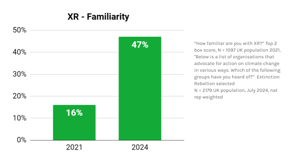](https://rebeltoolkit.extinctionrebellion.uk/uploads/images/gallery/2025-01/s25-6-images-for-rt.png)
A research study was conducted for Extinction Rebellion for this iteration of the strategy which used the 2021 XRUK Barriers to Engagement by the Data Analysis and Insights Circle in order to form a comparison. This work shows increased engagement in climate and activism generally, with a growing inclination towards active involvement in climate-related causes, and a significant increase in awareness of and familiarity with Extinction Rebellion. However, broadening out beyond climate as a galvanising issue reinforces only the base of support from the activism world, while actively discouraging the wider public. It is essential to understand where the public is in terms of Extinction Rebellion, other climate groups and with nonviolent direct action more generally. This helps us understand how to leverage our messaging for maximum impact.
[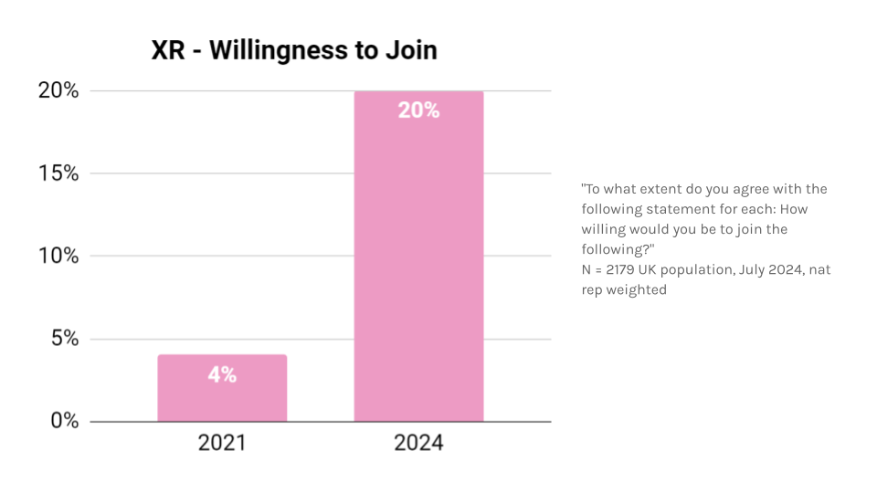](https://rebeltoolkit.extinctionrebellion.uk/uploads/images/gallery/2025-01/s25-6-images-for-rt-1.png)
Extinction Rebellion is a broad church, holding a variety of beliefs and hopes. Sometimes this means that an inconsistent image has been presented to the world. This is reflected in the data: the public has a confused understanding of who we are and what we want, and correspondingly lower levels of trust and belief that as a movement we are driven by good motives. Research on successful social movements tells us coherence and alignment on strategy, tactical plans and messaging are necessary. Holding the organisational discipline to present a coherent image of ourselves to the public is vital if we want our story to be the one that is told.
[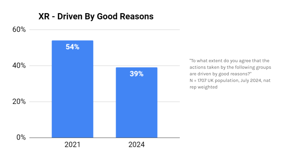](https://rebeltoolkit.extinctionrebellion.uk/uploads/images/gallery/2025-01/s25-6-images-for-rt-2.png)
We know from our research that the public, generally, cannot identify Extinction Rebellion's goals (only 12% of respondents correctly attribute the mission statement from our principle and values to us). Shaping public perception requires not only presenting ourselves effectively but also addressing the influence of media coverage and the public's tendency to group all NVDA under a single banner, often failing to distinguish between distinct movements, a trap we fall into ourselves. Our mission is one that is not widely recognised or understood, coming from a movement that has often been fragmented and in conflict with itself - that is not a movement that wins.
The findings of the strategic comms research challenge preconceptions about who we already resonate with. From an ethnicity perspective, white people are the most knowledgeable about Extinction Rebellion - and the group least likely to support us. Contrastingly those identifying as Black, African or Caribbean are more strongly supportive of Extinction Rebellion and more strongly in favour of NVDA in general. We see from our research base that people who are systematically disenfranchised by the system see more value in rebellion. We know, particularly in the case of climate, that is a large and growing potential audience. However while Black, African, and Caribbean communities are more strongly in favor of NVDA, marginalisation and concerns about unfair treatment by police and courts may lead to personal reluctance to participate - highlighting an ongoing source of tension.
We need to find which slices of the non-activated public can be reached now, and which ones could be reached later with some groundwork. Our strategic communications research can give us insights into how to do this. Community work opens the doors into those spaces, giving us the ability to energise and engage people we’ve never spoken to before. This provides a key opportunity to reintroduce ourselves, on our own terms.
Our 2023-24 strategy highlighted a vital audience: **ordinary people, who don’t identify with politics, and are not involved in campaigning.** The strategic communications project gives greater insight into this segment. They are generally indifferent to personal involvement in climate activism and political engagement. While they acknowledge the reality of climate change and believe it needs addressing, they don’t feel a personal responsibility to take action, often leaving it to others to drive change. People who view themselves as politically neutral, they avoid active support for any causes, including climate action. Though not deeply informed or politically active, they do recognise that broader efforts to address climate change haven't gone far enough, even if they don’t see resolving this gap as their personal responsibility. Further exploration on how to utilise these findings is key work for the months ahead.
Speaking with our own voice means we avoid the traps of ideology-based projects and campaigns and hold firm to our unique storytelling. We should find routes into messaging about interconnected issues in a way that brings a meaningful contribution, rooted in our own identity.
It is vital that as a movement we leverage the opportunities we have at this time. We should use the breadth of forms of media available to us, in a way that is consistent and powerful. Lack of awareness of who we are within key demographics affords the opportunity to reintroduce ourselves - not the media caricature, the real us. Ordinary people who are driven to extraordinary action by the crisis we face. Taking the image of us that is used to demoralise and deflect us and reframe it as something that is a source of strength.
**Key points**
* Speak with our own voice, and our own tone - punky, irreverent and authentic (with some humility!)
* Leading with the climate to find a way into interconnected issues
* Breaking into new audiences, and embracing the opportunity to reintroduce ourselves on our own terms
#### Community Bases of Power
Community building is an essential part of creating social change. Communities are the space between governments and individuals where people come together to create change for themselves. Building strong communities that are able to do this cannot be avoided; it is how power is built regeneratively from the ground up and only works at the speed of trust.
Thriving communities actively disempower the institutions that are not serving them. Effective local community and citizens’ assemblies bypass ineffective local authorities. Well-facilitated local meetings can amplify less-heard voices and organise around the skills, knowledge and experience that they already hold. Highly-targeted NVDA rooted in local knowledge and concerns can hold institutions to account where it matters most. Thriving communities can push against society’s extractivist systems, they are regenerative. The actions they take are not just sustaining but generate energy, drive and trust to foster the development of a future that they want to live in.
Extinction Rebellion is a huge community and we are creating change for ourselves in ways that are meaningful to us. We are brilliant at building trust with rebels quickly in a way communities of place often struggle to do. People and purpose are key foundations of trust building - our actions are really important here. They are where we come together as a movement, share our knowledge and skills in person and create change. But they cannot happen without the foundations of community behind them.
### “People who organised and engaged in community building in their neighbourhoods, towns and villages were the “cause” and the “I Have a Dream” speech was their “effect.””
~ Cormac Russell
This movement has created powerful groups of people who care deeply about the climate and each other. Groups that have each other's backs and support each other through some of the most stressful experiences activism can throw at them. We have created communities of care that turn out again and again and enable each other to act for the climate, our ecology and world. Our research shows we do this through at least thirteen processes of community building. These processes are co-created by every individual and not limited to roles. They are not a tick list and are never ‘complete’ but are ongoing in hundreds of tiny activities present in every encounter, meeting or action. Together we:
* Build trust
* Create and maintain connection
* Create safe space
* Build a shared sense of culture
* Create shared purpose
* Look to the boundaries of our groups and welcome people in
* Work out how to communicate meaningfully with each other
* Make collective and inclusive decisions
* Share skills and ideas
* Express ourselves creatively
* Celebrate and acknowledge the work we do and the wins we have
* Negotiate effectiveness in changing circumstances
* Look out for each others’ well-being
We have an opportunity to strengthen these processes and turn them outwards to the world, embedding ourselves in the social fabric of our local places. Strengthening these processes and acknowledging the work that already goes on (often unrecognised) in the movement is imperative. A healthy XR community is a stronger community, where well-being is co-created for each other, where individuals stay longer, are supported by each other, take on roles that play to their strengths and take action regeneratively.
This is becoming increasingly important in the UK today. The cost of living crisis reduces individuals' time and energy to act on the things they care about, disconnecting us from each other and our power to create change. And when we dissent, the brokers of top-down power know how to shut it down. Government structures are more robust and resilient than we want to admit. But what they cannot manage is communities that have built genuine power together, who are making collective decisions to change things for themselves.
Building communities means embedding ourselves in our localities and investing in authentic connections with a broad range of people. These connections are built through curiosity and enquiry, to find and act on shared points of caring. It means bringing our NVDA skills into the cultural life of our places and allowing others to bring their skills too. We cannot do everything ourselves, nor do we need to. We do not need everyone to act with us but we do need everyone to act on the climate and ecological crisis in ways that matter to them. As assemblies often show, people taking collective action on issues they care about can be more radical than any action an institution would take.
By embedding ourselves in our localities we also begin the work of co-creating alternative structures and enacting climate justice for each other. Empowering communities disempowers institutions that are either not serving them or are actively suppressing them. As the impacts of the CEE intensify, fewer institutions are serving communities. The connections of a community are how it builds resilience to mitigate and respond to these impacts.
**“For the most vulnerable in a prolonged and intense heatwave, community connections, not access to services are a matter of life and death.”**
Luckily the research into community building in Extinction Rebellion shows we have already begun this work in hundreds of communities across the UK. This is an amazing foundation on which to build. However the research also shows that this work is often overlooked, uncelebrated and not shared as much as it could be. We have to shout about it and share the skills, knowledge and experience we already have across the movement.
Communities are where deep and just change becomes possible beyond our movement. Turning what could be shallow gestures, performative allyship or single moments of protest into the creation of bases of power. Our actions are lightning strikes but we need to build the storm of cultural momentum behind them. This storm lies in communities where people recognise and learn from each other’s strengths, build trust, actively participate in collective decision making, stand up and create change in ways that matter to them.
**Key points**
* Actions are lighting strikes; we have to build the storm
* Keeping ourselves well enough to continue rebellion
* Community building is a regenerative action
* Operating on a human scale
* Climate justice is something that communities create for each other.
* Thriving communities actively disempower the institutions that are not serving them
---------------
### Case study
As a case study XR Rhythms are one of the best examples of **how XR builds community**. It is not by any means the only example, any of the activities present here are also abundant in other parts of the movement. Bands build community in two ways: within themselves, and in how they act as part of local communities.
**Build trust**
Trust is essential in a band, as no individual creates its sound alone. Trust develops through practice and time together. In action, drummers rely on trust to ensure safety for themselves and the public, stewards, whistlers, and shepherds manage external risks. This trust also extends to informed decisions around arrests. Bands have, without direction, encircled members targeted by police (due to age, sex, race, etc.) to help them leave safely. Bands are loud but being known as a considerate neighbours in local places builds up trust, negotiating practice space and showing up of local causes that intersect with XR ones is key here.
**Create and maintain connection**
Connection building begins on day one with every new drummer. All members help newcomers feel welcome, learn their part, follow signals, and adapt to the group's culture. Connections grow through regular practice, protests, and social time, strengthened by shared interests and purpose. In a local place connection is built broader by being visible in a space and owning elements of that local identity. This can be as simple as a name but also includes contributing to local festivals, elements of dress and customs in band culture.
**Create safe space**
The Rhythms community is a diverse one (especially in age and neurotype) which prioritises safe spaces, particularly at camps. Safe space is continually shaped by listening and collective learning. An accessibility coordinator helps with planning and is on-call during camp. Accommodations include rooms for non-campers, quiet spaces, adjusted schedules, and adapted workshops for additional needs. Conflict is held by designated individuals, but all attendees are asked to share responsibility for creating a safe space. This attitude is present in local groups, creating environments that a broader range of people want to participate in.
**Share skills and ideas**
In a band, skills sharing is power sharing. At their best, bands empower all members to play and whistle. This flexibility ensures members can switch roles seamlessly, making the band resilient and harder to disrupt on the street. Rhythms deliberately make a point of sharing skills freely, they have a cohesive and decentralised practice that can be picked up by anyone. In local places skill sharing is fun, bands run workshops for other groups. They also learn from others gaining techniques, inspiration, and connection in the process.
-----------------------------------
#### Together We Thrive
Extinction Rebellion must build genuine community power that reflects the full diversity of our society. Diasporic communities are not separate groups to be ‘included’ but integral parts of our society whose participation is essential in building the community bases of power needed to drive radical change. Bringing vital understanding of how collective power grows through sustained relationships and shared values, each generation can contribute different strengths to this power building. Faith groups, cultural institutions and regular acts of mutual support demonstrate how resilient community power develops when we genuinely work across the full spectrum of society.
The relationships maintained by diaspora communities naturally connect local action to global impact. Family ties and cultural bonds span borders, creating authentic pathways for understanding how change happens in different contexts. Their faith networks, cultural exchange and daily lived experience show us how global solidarity grows from real relationships and not simply from campaign moments and flashpoints. This matters profoundly for addressing the CEE, because climate breakdown affects communities everywhere, but its impacts fall heaviest on those who have done the least to cause it. This is obviously a commonly held view, but solidarity is a verb and it is incumbent on those in the UK to do better.
Overarching, transformation change on a worldwide level requires authentic global solidarity, not manufactured and transient moments of support. The networks maintained by diasporic communities provide natural pathways for understanding how climate impacts affect different communities and what kinds of support make a difference. These connections embed justice at the heart of our response, linking local and global struggles for climate justice through real relationships. This is how we build a movement capable of driving the radical change needed to address a crisis that transcends all borders.
**Key points**
* Look around you - Who are your neighbours? What are their experiences of the climate crisis? What is already being done in the UK?
* This is work that is going to look different across the movement, because the communities around us are different
* Extinction Rebellion being a part of authentic and genuine communities is a part of not only achieving cultural momentum but also being a part of real empowerment and change.
#### Systems of Change
Extinction Rebellion has built sophisticated systems and cultures to enable our work, from digital platforms and legal support to facilitation services and regenerative ways of working. Guided by a mature self-organising system, these essential functions include strong media and messaging capabilities, outreach and onboarding processes, and comprehensive support for local groups. Together they create a foundation that allows the organism to operate effectively. This support infrastructure requires ongoing care to remain resilient and responsive to the needs of the movement.
Much has been done to evolve our systems and cultures but it is recognised that its various functions must work better together to reduce conflict and internal friction. While each circle and role was created to address real needs, the resulting complexity strains our resources and creates coordination challenges that have been difficult to address. The movement must embrace the agility and intention of our self-organising systems (SOS) in order to ensure that Extinction Rebellion UK can function in a way that ensures long-term effectiveness and sustainability. Use and understanding of our SOS has continued to improve across the organism. This has thrown into sharp relief instances where we have failed to use it and the harm caused to rebels and to our ability to succeed.
The movement needs to continue to invest in thoughtful systems to facilitate reflection and learning and assess effectiveness in order to understand how well different activities contribute to the goals we have set – celebrating what has been achieved as well as seeking out potential for improvement. Expanding in-house data practices will support better decision-making and resource allocation and empower more teams to work in an evidence based way, helping build the resilience we need to mobilise sustainably.
Financial sustainability underlies all these challenges. Long-overdue improvements are being made to our financial structure, but this is only one step on that journey. Extinction Rebellion has always had an oversized impact relative to our financial leverage. We must ensure we are balancing fundraising capabilities that align with organisational needs and capacities with strategic spending decisions that look to ensure the ongoing health and sustainability of the movement. This is a marathon, not a sprint.
Harmonising structure, resources and collective will is a fundamental challenge the movement continues to struggle with. There are inherent tensions in a decentralised system, that the SOS was designed to address by providing a framework for autonomous decision making while maintaining strategic coherence. Where properly implemented and embraced, SOS has proven effective at reducing conflict, preventing burnout and enabling efficient collaboration. However some continue to view it as unnecessary bureaucracy that slows us rather than essential infrastructure which when used effectively allows us to be quick and agile. This often leads to lack of engagement or resistance that creates tension and is not aligned with the spirit of our SOS.
History shows that successful movements require organisational discipline in order to succeed, and in this SOS is fundamental to our work. The system offers vital tools for navigating complex organisational changes while maintaining distributed power and local autonomy. However, its effectiveness depends on genuine commitment from all parts of the movement.
In some cases, policies tailor-made to our unique circumstances may be appropriate. Creating a safe and regenerative culture is aided by having institutional rules in place for situations where a lack of alignment is leading to interpersonal conflict and blockages. We should explore the creation of transparent and objective processes that act to support rebels, ensure strategic alignment, and uphold the consent of the wider movement.
Addressing these interconnected challenges requires careful sequencing and clear communication. By thoughtfully streamlining structure and strengthening essential systems and support functions, Extinction Rebellion can create the organisational foundation needed for long-term success. This evolution will require engagement, compassion, and commitment from rebels throughout the organism, but will ultimately enable the movement to better serve its transformative mission.
**Key points**
* Continue to improve understanding and use of SOS and explore the solutions it offers for recurring issues
* Explore how our data collection can be a resource for UK circles
* Empower Fundraising with the tools to win
* Re-evaluate what our long-term financial model looks like
* Strategic and tactical alignment is vital for success - we need to be pushing in the same direction
#### This is What Democracy Looks Like
In observing policy-making processes we see legislators faced with competing interests, including media filtering, party point-scoring and electoral prospects, placating donors and big business, and even personal prospects for promotion. We do not witness a straightforward prioritisation of the national interest or common good. Even with the best intentions, parliamentarians are often unable to set aside considerations that are unrelated to the actual issue at hand. This simple reality is no different for any UK government, whatever party is in charge.
There should be no incentives other than the common good in public policy-making. Policies should be made within a system that has removed or relegated the other incentives. However, without pressure for new ways of doing things, the public simply turns ever more towards alternative narratives, some of them extremist, xenophobic and filled with hate. This is not surprising, given how much emphasis is placed on the need to trust institutions, including those we can all personally see and experience as failing and delivering negative outcomes.
The need to champion an upgrade to our democracy is still not breaking through into the public consciousness, despite how obvious it is that it is urgently needed. Our Third Demand calls for a UK-wide Citizens’ Assembly on Climate and Ecological Justice. We must root this demand within a wider purpose, understanding that on its own, such a citizens’ assembly is not likely to deliver the scale of change necessary. It is a critical first step that would represent a true breakthrough, but one that would still be subject to the compromised processes within Westminster.
Extinction Rebellion should not advocate specific reforms, no matter how fashionable, since they will only amount to tweaks at the margins, not fundamental change. We will not advocate electoral system changes such as proportional representation, but rather focus on driving cultural impetus for systemic change. These represent more profound changes to the very fabric of how politics in the UK operate, highlighting the desperate need for more participatory and pluralistic processes and the recognition of poorly understood but powerful tools on offer and already working well, that in the right circumstances enable deliberation to be undertaken properly, not tokenistically.
Community building combined with assemblies and consent-based decision making can shift thinking from tweaking the status quo to being truly paradigm breaking. In order to do this we must hold space with the full breadth of any given community. We cannot just be talking to ourselves or like-minded participants – that is ineffective.
XRUK supports a vision of democracy as a practice that members of a community co-create with each other, where it represents agency and empowerment, not an unfamiliar system that is imposed from elsewhere and drawn on for support when required. Decision making should default to the level closest to people and communities. Tools like assemblies and advanced meeting facilitation techniques are critical to moving towards a culture of participation, fairness and transparency.
Extinction Rebellion recognises that beyond the CEE, there is a huge danger of feelings of disempowerment and distrust being widespread in the UK. Rather than be distracted by calls for specific, moderate changes that will do little to change this course, we must hold our nerve and insist that visionary change is not only the best antidote, it is already within our grasp. Far more important than individual reforms is the reinvigoration of trust and person-to-person connection.
**Key points**
* Our Third Demand remains an essential part of the pathway for the movement
* The need to upgrade democracy is a powerful and unifying message
* Democracy is something we co-create and is a practice, not just a system.
#### Another World is ~~Possible~~ Necessary
The path that bridges our present reality to a liveable future is one that we must build together, step by step, community by community. This bridge, The Bridge, serves as both a metaphor and practical infrastructure of transformation, built from the connections we forge, the trust we build and the power we create through collective action in communities.
On one side of the Bridge stands our current world, trapped in cycles of extraction and isolation, where profit dictates decisions and individuals struggle alone against mounting crises. On the other lies, not a utopia, but a future where communities have rediscovered their power to shape their own destiny. Between these points lies the crucial work of transition, a space where we develop the tools, relationships and regenerative cultural practices that make a different future possible.
The bridge manifests through practical actions: neighbours sharing resources during heatwaves; communities making decisions together about local needs; networks of support spanning different backgrounds and beliefs. People power becomes a solid plank in the bridge to a better future. The transformation grows from thousands of small shifts: from competition to cooperation, from extraction to regeneration, from isolation to connection. We build by starting where we are, using what we have, beginning with what is strong, engaging everyone who wants to help create something better. Each community that rediscovers its collective power illuminates the path forward.
We need to build this bridge because we see the crumbling infrastructure of our current systems, the mounting pressures of climate change, and the failure of centralised power to serve common needs. When communities develop their collective power, they create resilience for future crises while discovering their capacity to shape the present. Through networks of mutual support, we create new forms of abundance. By practising collective decision-making, we make better democracy real.
The future on our current trajectory holds more isolation, more extraction, more collapse – but we can choose a different path through the work of building power together. This is our invitation. Not to imagine a perfect future, but to join the vital work of building The Bridge that leads there. The future emerges though everyone who chooses to participate, who brings their skills, hopes and determination to this transformation. We do not need to see the whole path to take the next step, knowing that the future is built through what we choose to create together.
**Key points**
* This is how we transition from our mission to our vision
* The breadth of the promise of our theories of change leads here
### Conclusion
This strategy reminds us what Extinction Rebellion is best at. It reinforces the need to reach the majority of people who want the same things as us, and that we already have the skills needed to do it. As we enter this pivotal year we will deepen our understanding of how to make our demands a reality in a world that acknowledges the crisis but remains locked in dangerous patterns of inadequate response. The work of holding decision makers accountable continues, strengthened by our deepened insight into the systemic barriers we must dismantle. 2025 marks a renewal of our commitment to the transformative change our world desperately needs.
Together, rooted in love, we are all we need.
### Everything is on fire, but everyone I love is doing beautiful things and trying to make life worth living, And I know I don't have to believe in everything, but I believe in that.
~ Nikita Gill
### Appendices
#### Glossary of Terms
Below are some of the key terms and concepts contained in this strategy that might benefit from
* **Wider Spectrum of Support** refers to the diversity and breadth of individuals, groups, and organisations, including those not previously aligned with the movement or its cause, who may actively endorse, participate in, or contribute to its goals.
* **Coalitions of Convenience** Often movements will work together to bring about one-off events or actions with the aim of raising awareness and applying pressure at necessary or opportune moments. Without ongoing in depth work on the issue at hand or to further a specific demand, however, these alliances become Coalitions of Convenience. Shows of unity across groups and mass numbers can help in maintaining media interest, but without committed work underlying them, along with Community Footprints, they risk becoming performative in nature, and are likely to have limited impact.
* **Spectrum of Activation** Not everyone reacts to the CEE the same way. Some people cycle to work a bit more, some go to prison, the reasons for those outcomes are manifold and complex. We need to understand that complexity better. Our work is to move people along the spectrum towards greater contention, but we lose millions of people focusing only on those prepared to break the law as they understand it.
Activists have a terrible habit of assuming that if we can’t see something on our own terms then it isn’t happening. “People don’t hit the streets over climate change because they don’t understand it” or “people unwilling to be arrested aren’t interested in seeing action”. This is untrue, it always was and holding onto it alienates the public in a way we can’t afford. We know that 80% of the UK public want to see more action on climate. We have support and goodwill, it’s out there. We need to interface with people, where they are, and encourage them to move along that spectrum towards greater contention, but in doing so, we cannot ignore the support we do have.
* **Community footprint** Few modern social movements are able to operate at both a national and local level. At the place based, local level, a community footprint means the individuals and activities are embedded in the life of the local community. This allows for building true, trust based relationships and also facilitates key feedback in real time from the grassroots to the national level. Community footprints are key to driving broad spectrum systemic change rather than narrowly defined policy changes.
* **Contention** refers to the deliberate use of confrontational or provocative actions to challenge systems, norms, or authorities, providing a framework to differentiate such tactics from non-confrontational actions that are safer and more accessible, without diminishing their value.
* **Cultural momentum** refers to the public and cultural conversation surrounding a movement's actions and underlying motivations, extending beyond mere support or approval to signify engagement with the issues being raised and their relevance to societal discourse.
* **Active community of practice** is a group of individuals who share a common interest or profession and actively engage in collective learning, knowledge-sharing, and skill development through ongoing collaboration, dialogue, and shared experiences.
* **Civil Disobedience** This is the intentional, nonviolent violation of laws or norms to protest against injustices or to bring attention to issues. It is often a moral or political act aimed at challenging unjust systems while respecting the broader principles of democracy and human rights.
* **Civil Resistance** The broader concept encompassing nonviolent actions taken to oppose oppression, advocate for rights, or achieve social, political, or economic change. It includes tactics like protests, strikes, boycotts, and non-cooperation, relying on collective power and strategic disruption rather than armed conflict.
#### Bibliography
The following bibliography contains some of the reading that has informed this iteration of strategy, in alphabetical order.
Bevins, V. (2023). If We Burn.
Bregman, R. (2020). Humankind: A Hopeful History. Bloomsbury Publishing PLC.
Chenoweth, E. (2019). Civil Resistance. Oxford University Press.
Corbet, S (2017) How to be a Craftivist: The Art of Gentle Protest.
Fisher, M. (2022). Capitalist Realism. John Hunt Publishing.
Finding spaces for change. (2007). Available at: [https://www.powercube.net/wp-content/uploads/2009/12/finding_spaces_for_change.pdf ](https://www.powercube.net/wp-content/uploads/2009/12/finding_spaces_for_change.pdf)
Garza, A, (2020) The Purpose of Power. Penguin Books
Graeber, D. (2018). Bullshit Jobs. New York: Simon & Schuster.
Guenther, G. (2024). The Language of Climate Politics. Oxford University Press.
Kelton, S. (2020). The Deficit Myth. Hachette UK.
Loach, M. (2023). It’s Not That Radical. DK.
Mazzucato, M. (2024). The Entrepreneurial State. Penguin.
Russell, C, (2020) Rekindling Democracy – A Professional's. Guide to Working in Citizen Space. Cascade Books
Russel, C. McKnight, J. (2023) The Connected Community: Discovering the Health, Wealth and Power of Neighbourhoods. Berrett-Koehler Publishers, Inc
Robin Wall Kimmerer (2013). Braiding Sweetgrass : Indigenous wisdom, Scientific Knowledge and the Teachings of Plants. Milkweed Editions.
Srdja Popovic and Miller, M. (2015). Blueprint for revolution : how to use rice pudding, lego men, and other non-violent techniques to galvanize communities, overthrow dictators, or simply change the world. Brunswick: Scribe Publications ; Scoresby.
Tree, I. (2019). Wilding. New York Review of Books.
Zeke Hausfather (2024). The growing carbon debt. [online] Theclimatebrink.com. Available at: [https://www.theclimatebrink.com/p/the-growing-carbon-debt](https://www.theclimatebrink.com/p/the-growing-carbon-debt)
**With Love & Rage, XRUK Strategy Team**