Sharing Events, Calendars or Maps
Sharing an Event from the Calendar
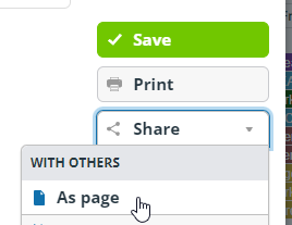
From within an event details window, use Share and then As Page This will give you a webpage with all the event details on.

Sharing Calendars
A useful feature if you want to share a pre-filtered version of the calendar with your teams. Maybe in your newsletters.
Simply add ?keywords=xxxxx (where xxxxx is the filter you want to apply) to the end of the url.
So for example the Midlands events would be https://teamup.com/kswyi17ixzj7f9i7fu?keywords=Midlands
The London events would be https://teamup.com/kswyi17ixzj7f9i7fu?keywords=London
Of course this assumes you do have that keyword somewhere in your events.
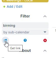
If you have a specific screen display with filters, a view and date ranges etc. then there is a small button just below the filter box that will generate a link to share

Embedding Calendars in your own Webpage
TeamUp provides a easy tool to create the code to embed a filtered version of the calendar in your own webpage https://calendar.teamup.com/kb/embed-teamup-calendar/
Sharing a Map
By adding a postcode in the url you can send a link to a map centered on a specific location (useful to add to your local group newsletters)
So https://eventmap.extinctionrebellion.uk/#OX16 would share a map centered on OX16 and zoomed to display at least 2 events
Sharing a personal map from within Action Network
By adding a link to an email (use the add link button) you can send rebels a link that will open the map centered on their postcode with a zoom to show at least two events.
If they have no postcode a UK map will be displayed.
https://eventmap.extinctionrebellion.uk/#{{ZipCode|default:'55.141209,-3.240964'|truncatewords:1,""}}/6/quarter/action,local,external//?no_rewrite=true
Map URL structure
The map URL fragment (the bit after the #) consists of the following elements, separated with slashes:
- Latitude,Longitude (of the map centre).
- This may be substituted for a full or partial (Outward) postcode. If you use a full postcode, eg PO381NL then it will work out that it should zoom in on PO38. Zoom level is ignored if a postcode is given.
- This may also be substituted for TWO lat longs separated by a colon. For example: https://eventmap.extinctionrebellion.uk/#55.141209,-3.240964:56.141209,-1.240964/6/week/action,local,external//
- This will load the map panned and zoomed to show the highest zoom level possible while both lat/long points are both visible. This is intended for use in iframes on local or regional websites, or other links where someone wants to ensure a whole area loads in view right away.
- Zoom level:
- numeric 1-19
- Time span:
- week
- month
- quarter
- Categories to show:
- action
- local * Training
- other
- Options
- minimal (small control), (this is the default if the map is opened on a mobile device)
- extra (big control),
- nowheel (disable mousewheel, recommended for iframe embedding).
- Search term
- the search term to filter by, if any. Nb. emoji will be encoded as UTF8 bytes.
- the search term to filter by, if any. Nb. emoji will be encoded as UTF8 bytes.
When the map is moved or settings changed, the URL updates. If you link to the page using a fragment that follows these rules, it will use those settings. This is ideal for embedding in iframes or including in emails etc.
